Columbia Basin Watershed Network
SGRC Lead Researcher: Ian Parfitt
SGRC Researchers: Justin Robinson
SGRC Intern: Barry McLane (2014), Venessa Langhorn (2015), Jan Pindroch (2016), Kalyn May (2017), Maggie Finkle-Aucoin (2018), Katie Erickson (2019) and Kyla Workun (2020)
Collaborating Agencies: Columbia Basin Watershed Network (CBWN) member groups
Funders: CBWN, CBT
The SGRC has provided GIS support to community-based watershed groups in the Columbia Basin since 2008. Projects include terrain mapping, off-road vehicle impact assessments, volunteer training, and mapping biodiversity data collected by citizen scientists. For more information about the CBWN please see www.cbwn.ca.
Resources
Mark / Mathew Creek (Mark Creek Recovery Program) — 2008
- Base Mapping Watershed Features (7.7 MB)
- Forestry Development Activity (7.7 MB)
- Mining Activity and Site Contamination (1.75 MB)
Joseph / Gold Creek (Joseph Creek Community Action Team) — 2008
- Base Mapping Watershed Features (6.8 MB)
- Forestry Development Activity ( 7.2 MB)
- Mining Activity and Site Contamination (7.1 MB)
- Wildlife Values (11.5 MB)
Salmo River (Salmo Streamskeepers Society) — 2009
- Salmo River Watershed (1.3 MB)
- Watershed Impacts (2 MB)
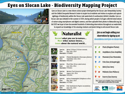
Slocan Lake (Slocan Lake Stewardship Society) — 2009
- Slocan Lake Hydrologic Features (11 MB)
Columbia Wetlands (Columbia Wetlands Stewardship Partners) — 2009
Jimsmith Lake Watershed (Jimsmith Lake Community Association) — 2010
- Jimsmith Lake Watershed Features (2.1 MB)
- Angus and East Angus Creek Survey (4.6 MB)
- Forest Coverage and Activities (2.9 MB)
- Wildlife Values & Non-Sensitive Endangered Plant and Animal Species (709 KB)
Lake Lillian (Toby Benches Society) — 2010
SHIM Mapping of Murphy, Hanna, & Topping Creeks, Rossland BC (Rossland Water Stewardship Task Force) — 2010
- SHIM Poster(4.5 MB)
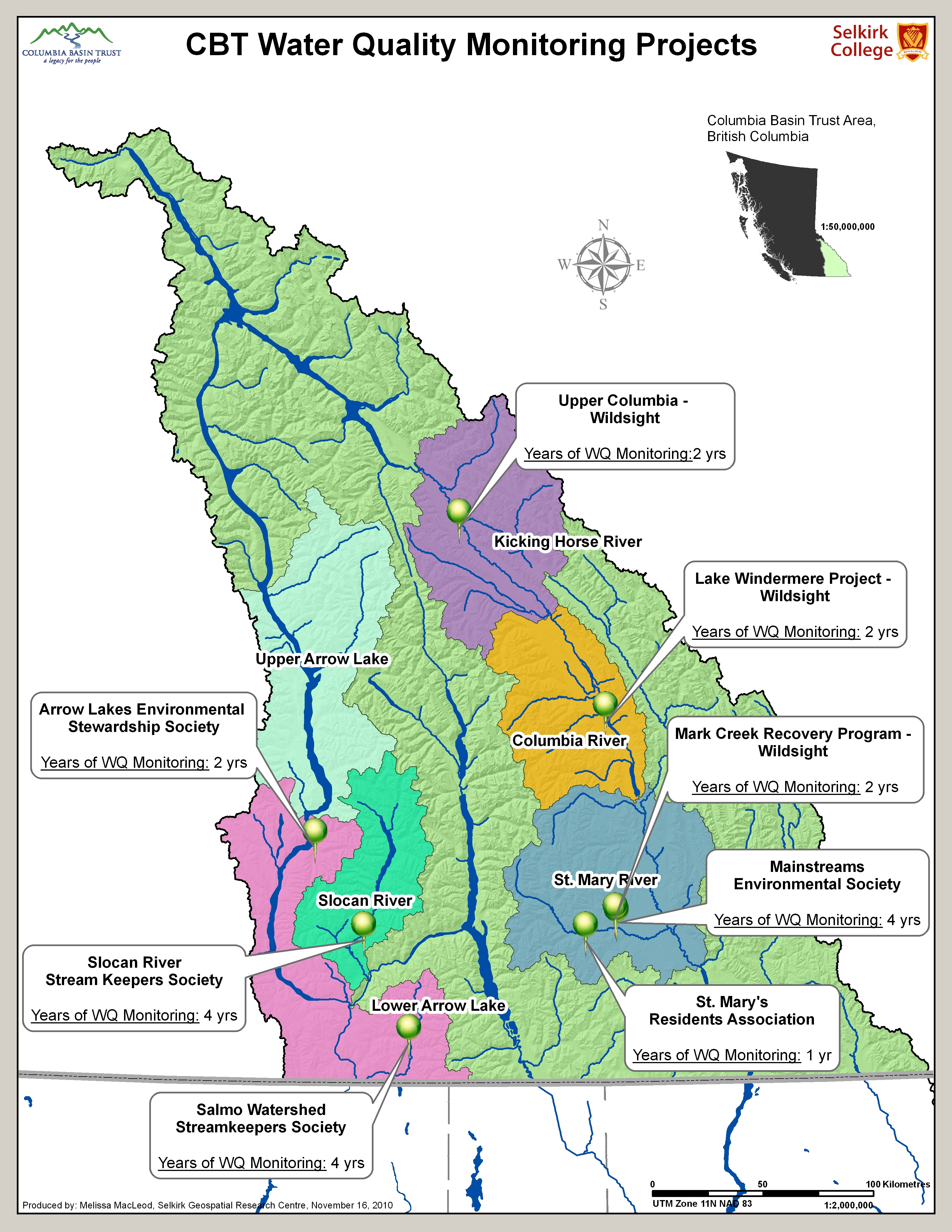
CBT Water Quality Monitoring Map — Nov 18, 2010
- WQ Monitoring Map (5.1 MB)
CBT Columbia River Watershed Simple Poster — Fall 2010
- A Simple Map Created of the CBT Area (3.4 MB)
Friends of the Lardeau River GIS & Mapping Support Project — Fall 2010
- The Lardeau River Watershed (low resolution version) (1.0 MB)
- A Simple Map of the Lardeau Watershed (0.5 MB)
- Fish Habitat Values Map (1.2 MB)
- Wildlife Habitat Values Map (1.2 MB)
- A Map of the Biogeoclimatic Ecosystem Zones(3.2 MB)
- Forest Cover Map (1.8 MB)
- Forest Activity & General Forest Ownership Map (1.6 MB)
- Mining Activity Map (1.9 MB)
- Parks and Protected Areas Map (1 MB)
- Terrain Stability Map (3.3 MB)
- Lardeau River Watershed: High Resolution Orthophotos and 20k Map Grid (0.7 MB)
- Ortho-mosaic of the Lower Lardeau River (Low Resolution Version) (0.5 MB)
- Ortho-mosaic of the Lower Duncan River (Low Resolution Version) (1.0 MB)
Elk River Alliance — Fall 2011
- Sensitive Habitat Inventory Mapping of Lizard Creek (10.6 MB)
- Lizard Creek SHIM Map Submission(309 KB)
Lake Windermere Ambassadors — Fall 2011
- Classified Aquatic Vegetation in Lake Windermere (4.9 MB)
- Aquatic Vegetation and Invasive Plant Species Survey Locations (4.9 MB)
- Provincially Regulated Speed Zone for Lake Windermere (4.5 MB)
- Provincially Regulated Speed Zone and Aquatic Vegetation (5 MB)
Mainstreams/Joseph CreekSummer/Fall 2012
- Basemap for Joseph Creek (22.7 MB)
- Biogeoclimatic Ecosystem Classification Zones for Joseph Creek (13.5 MB)
- Joseph Creek Watershed Forest Operability (13.4 MB)
- Joseph Creek Watershed Forest Ownership (14.9 MB)
- Joseph Creek Watershed "Hotspots" (15.5 MB)
- Joseph Creek Watershed Features & Licences (17.6 MB)
Springer Creek (Springer Creek Restoration & Preservation Alliance) — 2014
- Watershed Overview Map (1.1 MB)
- Village of Slocan Recreation Areas (1.9 MB)
- Springer Creek Trail Map Brochure (1.2 MB)
Slocan Lake (Slocan Lake Stewardship Society) — 2014
- Citizen Science Initiative Poster (4.1 MB)
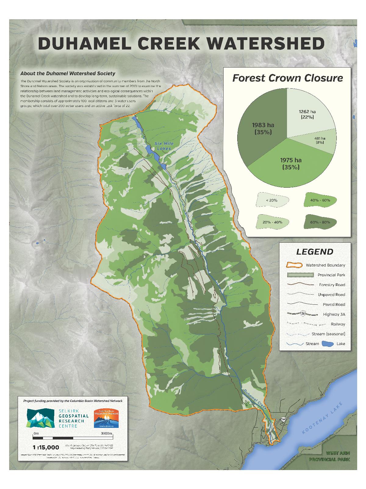
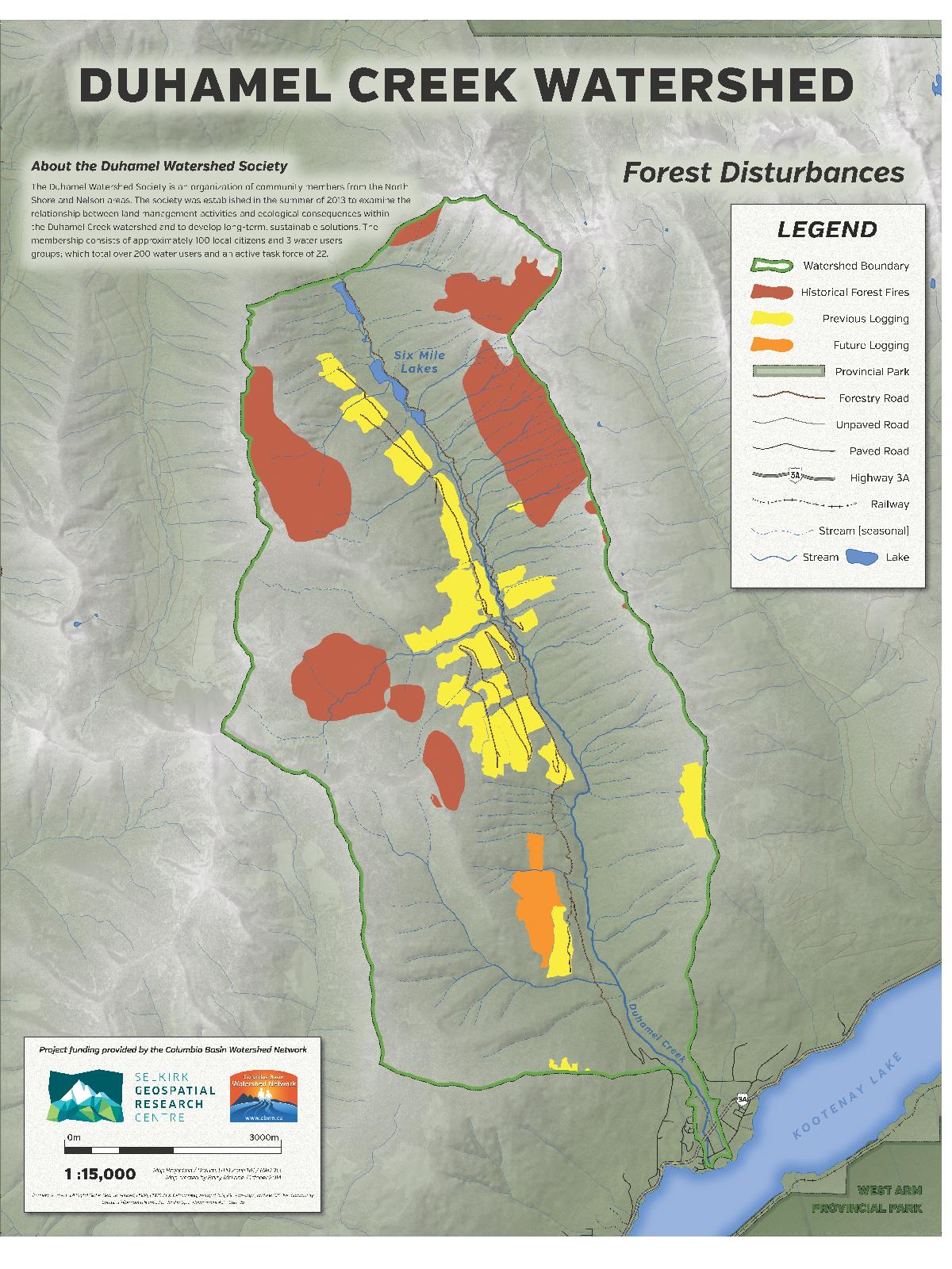
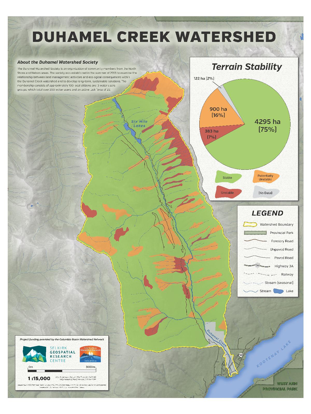
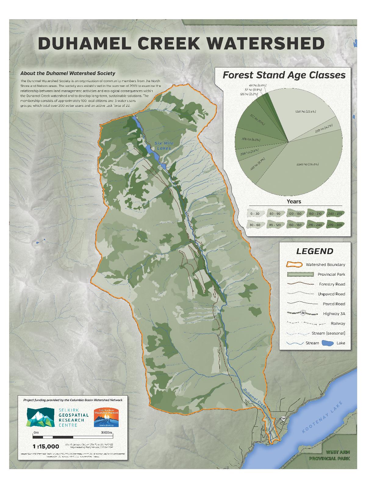
Duhamel Creek (Duhamel Watershed Society) — 2014
- Forest Closure Map (286 KB)
- Forest Disturbances Map (304 KB)
- Terrain Stability Map (284 KB)
- Forest Age Class Map (295 KB)
East Shore (East Shore Freshwater Habitat Society) — 2015
- Crawford Creek (6.9 MB)
- Crawford Creek Watershed (4.4 MB)
- East Shore Watersheds (4.3 MB)
Kootenay Lake (Friends of Kootenay Lake) — 2015
- Kootenay Lake Watersheds 8.5" x 11" (10 MB)
- Kootenay Lake Watersheds 33" x 44" (11 MB)
Flathead River Biomonitoring Program (Living Lakes Canada) — 2015
- Cate Creek Site Status (942 KB)
- Couldry Creek Site Status (860 KB)
- CABIN Monitoring Sites 2013 (1 MB)
- CABIN Monitoring Sites 2014 (1 MB)
- Flathead River Site Status 2013 (1 MB)
- Flathead River Site Status 2014 (1 MB)
- Howell Creek Site Status (1.3 MB)
- Sage Creek Site Status (1.3 MB)
Rossland (Rossland Streamkeepers) — 2015
Golden (Wildsight Golden) — 2015
- Columbia Wetlands Waterbird Survey (4.9 MB)
Blewett (Blewett Watershed Group) — 2016
- Forestry Disturbances (83 MB)
- Forestry Disturbances - Ledger Size (664 KB)
- Geology (90 MB)
- Geology - Ledger Size (803 KB)
- Hydrology (96 MB)
- Hydrology - Ledger Size (873 KB)
- Land Ownership (82 MB)
- Land Ownership - Ledger Size (648 KB)
- Recreational Activities (79 MB)
- Recreational Activities - Ledger Size (667 KB)
- Slope Stability (118 MB)
- Slope Stability - Ledger Size (812 KB)
Kootenay Lake (Friends of Kootenay Lake) — 2016
Golden (Wildsight Golden) — 2016
Wasa Lake — 2017
- Wasa Lake Land Improvement District (3 MB)
- Wasa Lake: Flood Elevations (3 MB)
- Wasa Lake Land Improvement District Watersheds (8.9 MB)
Mather Creek (Mainstreems) — 2017
- Mather Creek Basemap: Poster (6.1 MB), Letter (1.4 MB), Tabloid (1.8 MB)
- Mather Creek Watershed: Human Use: Poster (8 MB), Letter (2.3 MB), Tabloid (3.1 MB)
- Mather Creek Watershed: Wildlife: Poster (5.5 MB), Letter (1.4 MB), Tabloid (1.8 MB)
Glade Watershed — 2017
- Glade Watershed: Topo Basemap (14 MB)
- Glade Watershed: Topo Basemap (with Legend) (14 MB)
- Glade Watershed: Vegitation Resource Inventory (12 MB)
- Glade Watershed: Surficial Geology (16 MB)
- Glade Watershed: Ownership (14 MB)
Columbia-Shushwap Invasive Species Society — 2018
- Bullfrog Dispersal: Poster (33 MB), Letter (30 MB)
- Columbia-Shuswap Regional District Operating Area: Poster (6.8 MB), Letter (2.7 MB)
- Lower British Columbia with Major Rivers and Lakes: Poster (9.3 MB), Letter (3.0 MB)
- American Bullfrog Invasive Range in the Pacific Northwest: Poster (6.9 MB), Letter (3.2 MB)
Living Lakes Canada — 2018
Flathead River Biomonitoring Program: 2017 Status
- Flathead River Site (FLT04): With Harvest Reserves / Without Harvest Reserves
- Howell Creek Site (FLT06): With Harvest Reserves / Without Harvest Reserves
- Cate Creek Site (FLT07): With Harvest Reserves / Without Harvest Reserves
- Couldry Creek Site (FLT08): With Harvest Reserves / Without Harvest Reserves
- Sage Creek Site (FLT09): With Harvest Reserves / Without Harvest Reserves
Lake Windermere Ambassadors — 2019
- Public Access Points: Letter (2.5 MB) / 84" x 60" (7 MB)
Slocan River Streamkeepers — 2019
- Sensitive Ecosystem Inventory:
- Slocan Watershed Overview (68 MB)
Slocan Waterfront Restoration — 2019
Wildsight Golden — 2019
- Beaver Wetland Overview (with dams): Letter 8.5" x 11" (2.4 MB) / Tabloid 11" x 17" (2.4 MB)
- Beaver Wetland Overview (without dams): Letter 8.5" x 11" (2.4 MB) / Tabloid 11" x 17" (2.4 MB)
Liard Creek — 2020
- Current and Planned Development (3.4 MB)
- Forest Characteristics (3.6 MB)
- Geomorphology (3.2 MB)
- Soil Moisture Regime (3.2 MB)
- Sedimentation (3.6 MB)
- Surficial Materials & Bedrock (3.4 MB)
- Slope & Terrain Stability (4.3 MB)
- Texture of Surficial Materials (3.2 MB)
Lake Windermere Ambassadors — 2020
- Aquatic Vegetation (3.7 MB)
- Changes in Aquatic Vegetation Growth since 2011 (3.8 MB)
- Frequency Of Aquatic Vegetation Species Observations During Aquatic Invasive Species Sampling (2011 - 2019): Section A (5.8 MB)
- Frequency Of Aquatic Vegetation Species Observations During Aquatic Invasive Species Sampling (2011 - 2019): Section B (6.4 MB)
- Frequency Of Aquatic Vegetation Species Observations During Aquatic Invasive Species Sampling (2011 - 2019): Section C (6.4 MB)
- Frequency Of Aquatic Vegetation Species Observations During Aquatic Invasive Species Sampling (2011 - 2019): Section D (6.6 MB)
Rossland Streamkeepers — 2020
- Cambridge Creek and Violin Lake Letter 8.5" x 11" (1.6 MB) / Arch E 36" x 48" (1.6 MB)
- Cambridge Creek and Violin Lake - Satellite Letter 8.5" x 11" (1.7 MB) / Arch E 36" x 48" (2.4 MB)
- Cambridge Creek and Violin Lake Slope - Letter 8.5" x 11" (1.5 MB)
- Cambridge Creek and Violin Lake Landsat-8 Satellite - Letter 8.5" x 11" (1.6 MB)
- Cambridge Creek and Violin Lake - Landsat-8, August 20, 2019 vs April 28, 2020 Arch B 12" x 18" (1.3 MB)