Thesis Blog Post or.. The field work → computer work transition
By Jamiee Remond on 2020-04-03 01:00
I'm a former Recreation, Fish and Wildlife (RFW) student turned computer worker all because of Geographic Information Systems (GIS). It was an odd transition to be out doing field work while pursuing a GIS education through Selkirk College and eventually a GIS job. The job I accepted is Geospatial Analyst for the Northern Caribou Recovery Program. I am tasked to assist with locating areas that we can protect to connect caribou herds. Although RFW and GIS may not appear to have alot in common, the more you investigate both fields you realize how much they overlap.
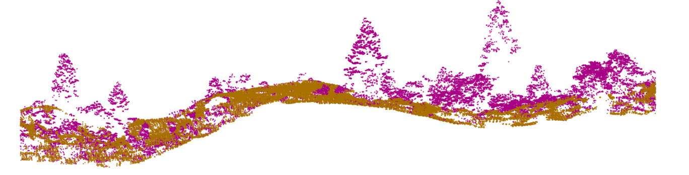
I never anticipated to be completing a thesis that involved both field work and extensive computer work but here I am! My thesis involved exploring how to use LiDAR in our local forests to classify evergreen and deciduous trees. LiDAR (or Light Detecting and Ranging) is a remote sensing tool that creates a dense cloud of points of features on the ground. Provided are some visuals of LiDAR to better understand:
You can start seeing real forest structure in these images -- this is what LiDAR produces. LiDAR also measures the intensity of the return of the laser pulse as an attribute. I wanted to test if this intensity could be used to classify trees and to explore how to get individual trees from this data. This is one small example of how GIS applications are relevant to the natural resources. If you're a field worker, you're most likely using aspects of GIS without fully realizing.
Through two different types of coding I achieved a 69% success of tree canopy type classification. This was done using two different programs or tools. First, I used R - an integrated set of data manipulation and calculation tools and Fusion -- a command line tool to process and visualize LiDAR to delineate individual trees from the forest. Once this step was complete, I measured the average, standard deviation and range of intensity values per tree. This created a threshold for different tree canopy types that I could apply to unclassified trees.
My results from this process were varied: for delineations of individual trees from the LiDAR point cloud, R only successfully identified 35.1% of trees whereas Fusion achieved 42.3% of delineations. There are several explanations as to how this turned out this way. Some of our local forests are within the Interior Cedar Hemlock (or ICH) zone which is known for high species diversity and productivity. This means our trees love to overlap, intertwine and compete with one another but that makes separating them difficult. Even if your standing below a canopy it can be difficult to see where one tree ends and the other starts -- the program has the same issues we do.
There are other contributing factors as to how this could be such as the quality of the LiDAR data and how it was collected but with refining and proper data collection this number could increase. LiDAR, like most technology fields, is still growing and new research is being conducted every day! A great paper entitled 'Early Detection of Invasive Exotic Trees Using UAV and Manned Aircraft Multispectral and LiDAR data' by Dash J, Watt M, Paul T, Monrgenroth J and Pear G has recently been released and I encourage a read.
This research demonstrates how LiDAR collected from an unmanned aerial vehicle (UAV) platform could detect invasive Pinus Ponderosa (Ponderosa Pine) seedlings when combined with multispectral imagery. They got the location of over 15,000 conifers to create this study but now it can be used beyond the timeline of the research. This allowed for the efficient location and treatment of the invasive tree on New Zealand's South Island. This study, as in many others, LiDAR is not the sole data used to classify tree species. The combination of LiDAR and imagery is the most used within most research.
If you're interested in the natural resources GIS is a great complimentary skill to add to your tool belt. If you take a point location of a plant, tree, animal or river and put it on a map -- you're doing GIS. The data you collect outside is only as good as it's being stored, analyzed or communicated out to the public. This is all done through GIS skills even when it may seem like it's not. The more you can dig in and learn about making a beautiful map, assessing the spread of an invasive plant or predicting the location of a wildlife animal based on habitat attributes the stronger the data you collected will be.
Be warned once you begin to dive down the rabbit hole that is GIS and all the branching off specializations you may realize you've been at your computer for over a year! There's plenty of perusable projects out there to combine your love for the outdoors and satiate your GIS thirst -- all it takes is interest, dedication and a whole bunch of googling!
Jamiee Remond