Forestry Innovation Technology Cluster
Selkirk College’s forestry innovations research team supports industry in the application of new, innovative technologies designed to enhance our forestry sector.
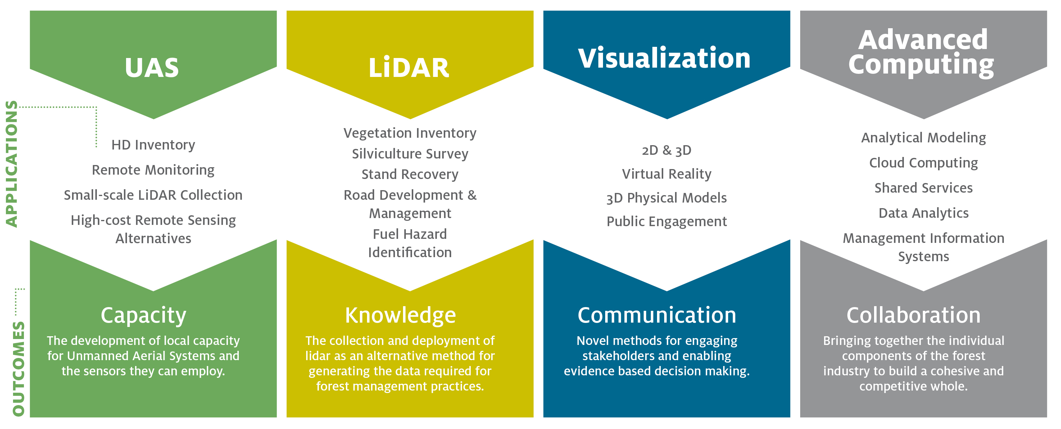
This program is designed to create a technology cluster focusing on innovative forest technology practices, primarily within 4 categories: UAS (unmaned aerial systems), Lidar, Visualisation, and Advanced Computing.
Objectives of the research program are: to enhance our local forestry cluster by facilitating the adoption of innovative technologies; to support the transition to a technologically-advanced, globally-competitive cluster through workforce training; and create an industry-college relationship that enables educational delivery that is responsive to rapidly changing workforce needs.
The capacity to increase efficiency and improve sustainable practices is fundamental to the cluster's ability to adapt to a changing environment and ongoing uncertainty in global markets. This investment will provide opportunities to optimize processes, decrease costs, enhance efficiency, and increase productivity and competitiveness. The need for enhanced training and skills development within the cluster is also critical. The current pace of technological development means that the workforce requires a range of technology skills, including the capability to use rapidly-evolving hand-held electronic devices alongside traditional approaches. Equipping our students and those employed within the cluster with the necessary skills to master these new technologies is a critical aspect of innovation, technology adoption, and competitiveness.
About the Pillars
Unmanned Aerial Systems (UAS) Applications
Selkirk College has been developing UAS capability since 2014. UAS technology provides researchers and industry with the ability to capture very high spatial resolution data at a very low cost. Current forestry applications of UAS include: reconnaissance surveys of cutblocks to ensure compliance with harvest or silviculture regulations; videos of wildland-urban interface treatments for public engagement; infrared images of fire hotspots; and vegetation composition, health, and productivity estimation with multi- and hyperspectral sensors.
Lidar
Lidar (or laser altimetry) uses laser pulses and a light sensor to measure distances to features. The regional forest industry has invested heavily in lidar over the past 2-3 years. Traditional road layout methods relying largely on field surveys have been replaced with office based methods using highly accurate digital elevation models (DEMs) derived from lidar: the cost savings of this advancement alone pays for the lidar surveys. More recently lidar has been used to create treelevel inventories where every tree over 10m high can be detected, and accurately identified by species, volume, and height. Lidar can also be used to estimate forest fuel loading and biomass. The SGRC has been involved with the Columbia Basin Glacier and Snow Research Network (CBGSRN) project that has been using lidar to measure snow accumulations and glacier volumes in the Columbia Basin. Snow accumulation and melt drives hydrology in the region and is affected by forest harvesting and so is a critical factor in forest harvesting development planning. Lidar holds major potential for quantifying the effect of forest removal and forest regeneration on watershed hydrology.
Visualization
Maps, photographs, perspective views, and 3D models leverage our powerful visual cortex to efficiently bring vast amounts of information into our minds. A large part of the power of maps, and geomatics, stems from the ability of these tools to convey big data. The recent development of lidar, high resolution imagery, and 3D technologies allows us to create ever more visually realistic models. Interactive 3D models can now be created with photogrammetry software from a set of overlapping geo-located photographs as well as from lidar. These models can be viewed on screens or through more immersive devices like augmented or virtual reality (AR/VR) headsets. The forest sector uses visualization in planning, operations, and public consultation processes. Visualization has always been at the core of Selkirk's Advanced Diploma and Bachelor of GIS programs. Communication with maps is a key learning outcome in many of our courses.
Advanced Computing
Cloud services leverage the high-speed internet, inexpensive data hosting, online processing, and easily extendable virtual machines residing on hardware in vast datacenters. Cloud services also can be shared among many users, reducing the cost to each user and increasing the number of potential users of an application. Multiple devices or sensors can be connected, creating the internet of things (IoT). Data analytics tools are a fundamental component of GIS that make use of the databases linked to the spatial features. Forest companies use a wide range of cloud services for planning and operations activities. One major challenge the industry faces in adopting cloud technology is connectivity in the back country since much of the forest landbase is beyond WiFi or cell coverage. Cheaper satellite communications or emerging technologies like LoRa (low power wide area – https://www.lora-alliance.org/technology) networks may solve this problem. Selkirk's Internet Mapping course explores the ever-changing web mapping world, and the SGRC has developed many internet mapping applications. The Centre has partnered with local forest companies and the provincial forest managers to develop a cloud-based, data analytics reporting suite to support multiobjective planning (the Higher Level Plan Objectives Reporting Suite – HLPO).
Current Projects
Lidar-based Hydrological Recovery
In snowmelt-dominated regions forest removal affects the hydrology of a watershed including the frequency of flooding (Green and Alila, 2012). To date, there have been few published studies in the Kootenay-Boundary region geared at quantifying incremental changes in snow accumulation and melt in forest openings and regenerating stands. This lack information on hydrological recovery results in uncertainty regarding sustainable rates of cut in watersheds. Traditional methods of assessing these impacts have relied on labor-intensive, field-based surveys of SWE conducted over many years. Recent technological advances in stand-level snow depth monitoring using airborne and UAV LiDAR surveys allows the question of hydrological recovery to be addressed much more rapidly than traditional field-based studies. Regionally-applicable data on the influence of forest stand height, canopy density and stand density on processes of snow accumulation and melt will reduce uncertainty concerning the potential for harvesting related impacts to aquatic values including volume and timing of runoff. This project proposes to explore the use of UAV-based lidar and multi-spectral imagery in forested mountain stands during the snowmelt period over a range of elevations, aspects and forest stands types to determine if this technology can be applied by forest licensees to assess the condition of hydrological recovery in forested mountain watersheds.
Fibre Inventory and Biomass Utilization Enhancement
Any timber that is merchantable, was not removed from the cut block and was not reserved for harvesting is called wood waste. This can be felled timber left on site—such as tree tops and branches or standing timber—that was planned to have been felled and removed. According to the BC government statistics, from 2004 to 2008, 4.3% of the harvested amount was wood waste or forest residues. Current regulations enable licensees to extract any logs of value to them within the cut block and to leave uneconomical lower quality wood when the cost of falling, yarding, trucking and milling it exceeds the value of the end product. However, the process of measuring the volume, and assessing the value and quality of standing or felled wood waste remaining on site following logging is a time and money consuming process. Higher utilization rates for wood waste could bring both environmental and economic benefits. However, past efforts to commercialize waste materials have met with challenges related to market identification, transportation and processing
The goal of this project is to improve access to the environmental and economic benefits that may accompany higher rates of biomass utilization by evaluating possible solutions to challenges associated with quantification and commercialization