

Mark / Mathew Creek (Mark Creek Recovery Program) — 2008
- Base Mapping Watershed Features (7.7 MB)
- Forestry Development Activity (7.7 MB)
- Mining Activity and Site Contamination (1.75 MB)
Joseph / Gold Creek (Joseph Creek Community Action Team) — 2008
- Base Mapping Watershed Features (6.8 MB)
- Forestry Development Activity ( 7.2 MB)
- Mining Activity and Site Contamination (7.1 MB)
- Wildlife Values (11.5 MB)
Salmo River (Salmo Streamskeepers Society) — 2009
- Salmo River Watershed (1.3 MB)
- Watershed Impacts (2 MB)
Slocan Lake (Slocan Lake Stewardship Society) — 2009
- Slocan Lake Hydrologic Features (11 MB)
Columbia Wetlands (Columbia Wetlands Stewardship Partners) — 2009
Jimsmith Lake Watershed (Jimsmith Lake Community Association) — 2010
- Jimsmith Lake Watershed Features (2.1 MB)
- Angus and East Angus Creek Survey (4.6 MB)
- Forest Coverage and Activities (2.9 MB)
- Wildlife Values & Non-Sensitive Endangered Plant and Animal Species (709 KB)
Lake Lillian (Toby Benches Society) — 2010
SHIM Mapping of Murphy, Hanna, & Topping Creeks, Rossland BC (Rossland Water Stewardship Task Force) — 2010
- SHIM Poster(4.5 MB)
CBT Water Quality Monitoring Map — Nov 18, 2010
- WQ Monitoring Map (5.1 MB)
CBT Columbia River Watershed Simple Poster — Fall 2010
- A Simple Map Created of the CBT Area (3.4 MB)
Friends of the Lardeau River GIS & Mapping Support Project — Fall 2010
- The Lardeau River Watershed (low resolution version) (1.0 MB)
- A Simple Map of the Lardeau Watershed (0.5 MB)
- Fish Habitat Values Map (1.2 MB)
- Wildlife Habitat Values Map (1.2 MB)
- A Map of the Biogeoclimatic Ecosystem Zones(3.2 MB)
- Forest Cover Map (1.8 MB)
- Forest Activity & General Forest Ownership Map (1.6 MB)
- Mining Activity Map (1.9 MB)
- Parks and Protected Areas Map (1 MB)
- Terrain Stability Map (3.3 MB)
- Lardeau River Watershed: High Resolution Orthophotos and 20k Map Grid (0.7 MB)
- Ortho-mosaic of the Lower Lardeau River (Low Resolution Version) (0.5 MB)
- Ortho-mosaic of the Lower Duncan River (Low Resolution Version) (1.0 MB)
Elk River Alliance — Fall 2011
- Sensitive Habitat Inventory Mapping of Lizard Creek (10.6 MB)
- Lizard Creek SHIM Map Submission(309 KB)
Lake Windermere Ambassadors — Fall 2011
- Classified Aquatic Vegetation in Lake Windermere (4.9 MB)
- Aquatic Vegetation and Invasive Plant Species Survey Locations (4.9 MB)
- Provincially Regulated Speed Zone for Lake Windermere (4.5 MB)
- Provincially Regulated Speed Zone and Aquatic Vegetation (5 MB)
Mainstreams/Joseph CreekSummer/Fall 2012
- Basemap for Joseph Creek (22.7 MB)
- Biogeoclimatic Ecosystem Classification Zones for Joseph Creek (13.5 MB)
- Joseph Creek Watershed Forest Operability (13.4 MB)
- Joseph Creek Watershed Forest Ownership (14.9 MB)
- Joseph Creek Watershed "Hotspots" (15.5 MB)
- Joseph Creek Watershed Features & Licences (17.6 MB)
Springer Creek (Springer Creek Restoration & Preservation Alliance) — 2014
- Watershed Overview Map (1.1 MB)
- Village of Slocan Recreation Areas (1.9 MB)
- Springer Creek Trail Map Brochure (1.2 MB)
Slocan Lake (Slocan Lake Stewardship Society) — 2014
- Citizen Science Initiative Poster (4.1 MB)
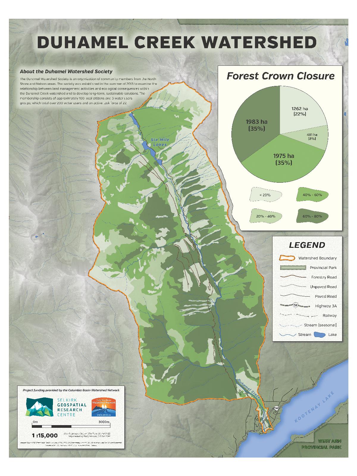
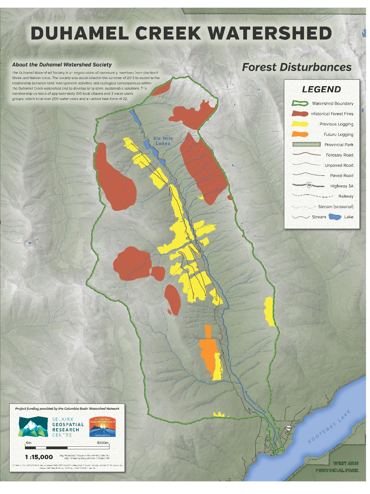
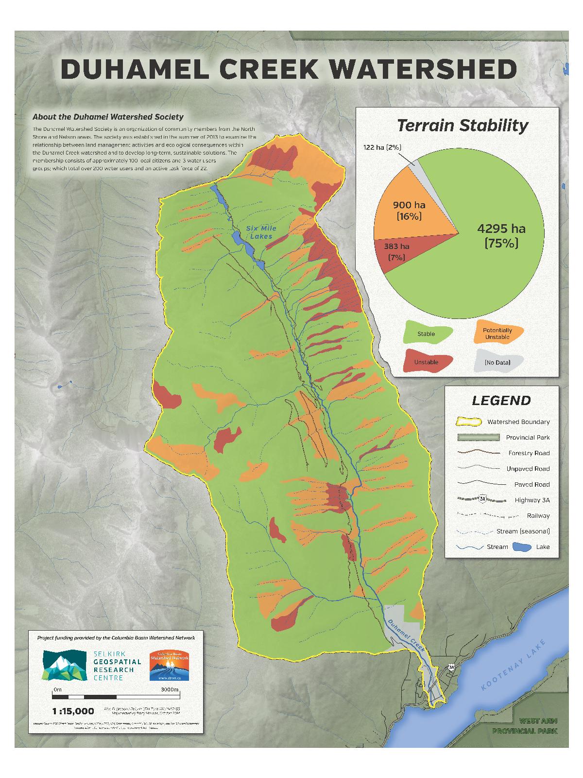
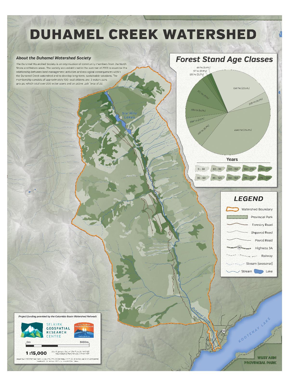
Duhamel Creek (Duhamel Watershed Society) — 2014
- Forest Closure Map (286 KB)
- Forest Disturbances Map (304 KB)
- Terrain Stability Map (284 KB)
- Forest Age Class Map (295 KB)